More Sacramento region rain, Sierra snow

Wet weather continues in Northern California on Sunday and more rounds are expected through early Wednesday with whiteout conditions that will make Sierra travel hazardous. Here is what to expect. | Send us your weather video here | Click here for the latest school closure information | Check the latest chain controls and road conditions here SNOW FORECASTExpect steady snow to develop in the Sierra by midday, Meteorologist Eileen Javora says. The snow level will lower to around 2,500 feet with a foot of snow possible near the passes by evening. There could be a dusting of snow as low as 2,000 feet. | MORE | Northern California Storm Coverage: Sierra travel not recommended as low-elevation snow falls You can then expect drying into the overnight with mainly dry conditions to start Monday. KCRA 3’s weather team is calling Monday and Tuesday Impact days because of fairly low snow levels and heavy snow with whiteout conditions that will disrupt Sierra travel.Snow will intensify Monday midday and will be heavy into the afternoon with gusty winds and whiteout conditions. Snow levels will drop to around 2,000 feet with some communities seeing minor accumulations on Monday and Tuesday. There could be a dusting of snow at 1,500 feet. The highest elevations in the Sierra may see 5-6 feet of snow by early Wednesday. RAIN FORECASTExpect rain to increase by late morning to midday on Sunday. It will turn breezy, with gusts of 25-30 mph, though rain amounts look light. The Valley still looks to get .25 of an inch of rain. Monday and Tuesday’s system looks wetter and colder than Sunday’s. Rain and some gusty winds will develop Monday by late morning into midday with the most rain likely in the afternoon. Another wave of showers is expected during the day on Tuesday.In total, the Valley may see around an inch of rain by Wednesday morning from these systems. Download our app for the latestHere is where you can download our app for the latest weather alerts.Track interactive, Doppler radar(App users, click here to see our interactive radar.)Real-time traffic map(App users, click here to see our real-time traffic map.)Follow our KCRA weather team on social mediaChief Meteorologist Mark Finan on Facebook and TwitterMeteorologist Tamara Berg on Facebook and TwitterMeteorologist Eileen Javora on FacebookMeteorologist Dirk Verdoorn on FacebookMeteorologist/Climate Reporter Heather Waldman on Facebook and TwitterWatch our forecasts on TV or onlineHere’s where to find our latest video forecast. You can also watch a livestream of our latest newscast here. The banner on our website turns red when we’re live.We’re also streaming on the Very Local app for Roku, Apple TV or Amazon Fire TV.
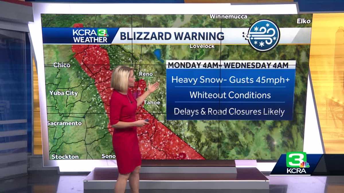
Wet weather continues in Northern California on Sunday and more rounds are expected through early Wednesday with whiteout conditions that will make Sierra travel hazardous.
Here is what to expect.
| Send us your weather video here | Click here for the latest school closure information | Check the latest chain controls and road conditions here
SNOW FORECAST
Expect steady snow to develop in the Sierra by midday, Meteorologist Eileen Javora says. The snow level will lower to around 2,500 feet with a foot of snow possible near the passes by evening.
There could be a dusting of snow as low as 2,000 feet.
| MORE | Northern California Storm Coverage: Sierra travel not recommended as low-elevation snow falls
This content is imported from Twitter.
You may be able to find the same content in another format, or you may be able to find more information, at their web site.
You can then expect drying into the overnight with mainly dry conditions to start Monday.
KCRA 3’s weather team is calling Monday and Tuesday Impact days because of fairly low snow levels and heavy snow with whiteout conditions that will disrupt Sierra travel.
Snow will intensify Monday midday and will be heavy into the afternoon with gusty winds and whiteout conditions.
Snow levels will drop to around 2,000 feet with some communities seeing minor accumulations on Monday and Tuesday. There could be a dusting of snow at 1,500 feet.
The highest elevations in the Sierra may see 5-6 feet of snow by early Wednesday.
RAIN FORECAST
Expect rain to increase by late morning to midday on Sunday. It will turn breezy, with gusts of 25-30 mph, though rain amounts look light. The Valley still looks to get .25 of an inch of rain.
Monday and Tuesday’s system looks wetter and colder than Sunday’s. Rain and some gusty winds will develop Monday by late morning into midday with the most rain likely in the afternoon.
Another wave of showers is expected during the day on Tuesday.
In total, the Valley may see around an inch of rain by Wednesday morning from these systems.
Download our app for the latest
Here is where you can download our app for the latest weather alerts.
Track interactive, Doppler radar
(App users, click here to see our interactive radar.)
Real-time traffic map
(App users, click here to see our real-time traffic map.)
Follow our KCRA weather team on social media
Watch our forecasts on TV or online
Here’s where to find our latest video forecast. You can also watch a livestream of our latest newscast here. The banner on our website turns red when we’re live.
We’re also streaming on the Very Local app for Roku, Apple TV or Amazon Fire TV.


You must be logged in to post a comment Login